-
×
 Jetboil Mightymo Stove
1 × $46.16
Jetboil Mightymo Stove
1 × $46.16 -
×
 National Geographic 703 Manti La-Sal National Forest Map Utah
1 × $9.32
National Geographic 703 Manti La-Sal National Forest Map Utah
1 × $9.32 -
×
Gear Yakima HitchLock
1 × $23.20
-
×
National Geographic 501 Moab South Trail Map Utah Gear
1 × $9.80
-
×
MSR Windpro II Stove
1 × $97.16
-
×
GSI Outdoors Gear GSI Coffee Percolator Bubble Top
1 × $4.11
-
×
National Geographic 203 Guadalupe Mountains National Park Map Texas
1 × $10.91
 National Geographic 703 Manti La-Sal National Forest Map Utah
  Gear Yakima HitchLock
  National Geographic 501 Moab South Trail Map Utah Gear
 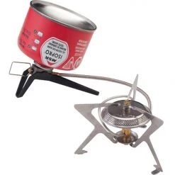 MSR Windpro II Stove
  GSI Outdoors Gear GSI Coffee Percolator Bubble Top
 Sale!

National Geographic 119 Yampa – Gore Pass Map
Original price was: $5.95.$4.28Current price is: $4.28.
- Buy quality, buy with us.
- Online assistance, always just a message away.
- Peace of Mind with Every Purchase
- Get the quality you deserve, for less.

The National Geographic -Trails Illustrated folded map is your essential guide for outdoor exploration in Colorado’s Yampa/Gore Pass area. The brilliantly illustrated topographical representation shows all trails, campsites, and recreational features, plus relevant info on wildlife, history, geology, and archaeology.
Coverage includes Routt and Arapaho National Forests. Sarvis Creek Wilderness. Toponas, Phippsburg and Yampa. Pine Mesa and Eagle Rock lakes and Red Dirt Resv. Gore and Lynx passes.
All data is updated to reflect road closings, new trails, and campground relocation.
Printed on waterproof, tear-resistant material with a plastic coating that offers supreme durablity for your next outdoor adventure.
Measures 4″ x 9″ folded and 28″ x 32″ fully opened.
Be the first to review “National Geographic 119 Yampa – Gore Pass Map”
Related products
Sale!

Original price was: $14.95.$12.41Current price is: $12.41.
Sale!

Original price was: $14.95.$10.91Current price is: $10.91.
Sale!

Original price was: $14.95.$10.91Current price is: $10.91.
Sale!

Original price was: $14.95.$12.26Current price is: $12.26.
Sale!

Original price was: $11.95.$8.72Current price is: $8.72.
Sale!

Original price was: $14.95.$10.91Current price is: $10.91.
Sale!

Original price was: $14.95.$11.66Current price is: $11.66.
Sale!

Original price was: $14.95.$10.91Current price is: $10.91.
Reviews
There are no reviews yet.